
View of a collapsed building after a strong earthquake struck central Myanmar on March 28, 2025.
| Photo Credit: Reuters
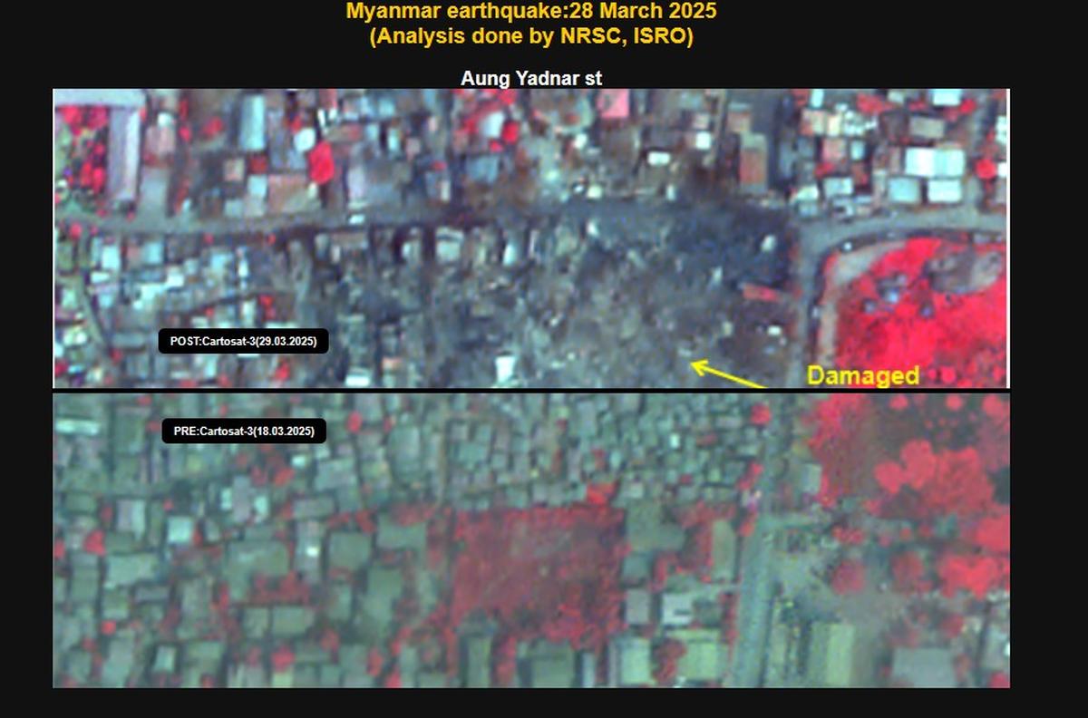
ISRO has released images captured by its earth imaging and mapping satellite, CARTOSAT-3 showcasing the damages caused by the earthquake in Myanmar on March 28.
The post-disaster Cartosat-3 imagery was acquired by ISRO on March 29 over the cities of Mandalay and Sagaing in Myanmar, it said.

Additionally, the pre-event Cartosat-3 data acquired on March 18 covering the same area was referred for change analysis and assessment of damage, the space agency said.
CARTOSAT-3 is a third generation agile advanced satellite having high resolution imaging capability.
“Significant damage to infrastructure in Mandalay city was observed, with major landmarks such as Sky Villa, Phayani Pagoda, Mahamuni Pagoda and Ananda Pagoda, University of Mandalay and several others suffering either complete or partial damage. In Sagaing city, damage was observed in the Ma Shi Khana Pagoda, along with several monasteries and other buildings,” the ISRO said in a statement.

According to ISRO, as seen from the imagery, the earthquake caused the complete collapse of the historic Ava (InnWa) Bridge on the Irrawaddy River near Inn Wa City. Cracks, ground ruptures in flood plains of Irrawaddy river with associated liquefaction was also observed.
In the statement, the space agency noted that an earthquake of magnitude 7.7 struck Myanmar on March 28 followed by strong aftershock of magnitude 6.4. The epicenter is located at 22.013° N 95.922° E at a depth of 10 km near Sagaing-Mandalay border.
It further said that the epicenter of the quake was located near Mandalay, Myanmar’s second-largest city, which experienced severe damage. The earthquake also rattled the capital Naypyidaw and other regions, resulting in the collapse of infrastructure, roads and residential buildings.
“The tremors were felt not only in Myanmar but also in neighbouring countries. The shockwaves were strong enough to be felt as far as Chiang Mai and northern parts of Thailand, where residents reported damages,” it added.
Published – April 01, 2025 10:08 am IST
#ISROs #CARTOSAT3 #images #show #damages #caused #earthquake #Myanmar
ISRO’s CARTOSAT-3 images,ISRO’s CARTOSAT-3 images show damages of Myanmar earthquake,Myanmar earthquake, earth imaging and mapping satellite
latest news today, news today, breaking news, latest news today, english news, internet news, top news, oxbig, oxbig news, oxbig news network, oxbig news today, news by oxbig, oxbig media, oxbig network, oxbig news media
HINDI NEWS
News Source