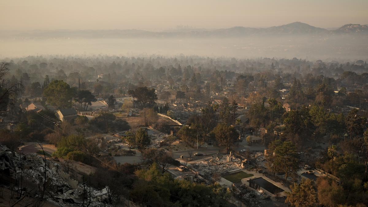
In the week since the fires in the Los Angeles County broke out, which have destroyed thousands of homes, at least 24 lives have been lost and 16 people were reported missing.
The 24 deaths were attributed to the two major fires raging across the county: the Eaton fire, which accounted for 16 of them and the Palisades fire (8). About 1,50,000 people in the county remain under evacuation orders, with more than 700 residents taking refuge in nine shelters.
Also Read: Los Angeles investigates fire blame as curfew enforced
Since January 7, the major fires that broke out are shown in the map below. Out of the six fires shown, three of them, namely the Lydia, Kenneth and Archer fires were fully contained. Hurst fire, which expanded to 799 acres, is almost fully contained as of January 13, according to Cal Fire which is The Department of Forestry and Fire Protection in California.
Source: Cal Fire; Map: Gautam Doshi
Only 13% of the Palisades fire, which spans over 23,000 acres, is contained; and around 27% of the Eaton fire, which spans over 14,000 acres, is contained, according to Cal Fire.
Charred neighbourhoods
The Palisades and Eaton fires have burnt and destroyed entire residential neighbourhoods, including buildings, businesses, outbuildings and vehicles. Over 12,000 buildings are estimated to have been burnt, with around 11,000 structures being damaged or destroyed by January 9, an analysis by remote sensing experts, which is mentioned below, showed.
The Palisades Fire
From January 7 to January 10, the Palisades fire quickly engulfed over 21,500 acres. And from January 10 until January 12, the fire spread over 5,000 acres more, thereby engulfing a total of 27,713 acres.

Source: Cal Fire; Map: Gautam Doshi
An analysis conducted through satellite data on January 9 by Jamon Van Den Hoek of Oregon State University and Corey Scher of the CUNY Graduate Center, accessed by The Hindu, shows the extent of the damage the Palisades and Eaton fires. In the Pacific Palisades, the map below shows entire neighbourhoods being burnt.
Shown in the maps below are small areas within the perimeter of the fires where most structures (residential and others) are present. The buildings or structures marked in red are damaged or destroyed by the fire, while the ones in grey are not likely to be damaged.

Source: Damage analysis of Copernicus Sentinel-1 satellite data by Corey Scher of CUNY Graduate Center and Jamon Van Den Hoek of Oregon State University. Oak Ridge National Laboratory (ORNL); Federal Emergency Management Agency (FEMA) Geospatial Response Office USA Structures; Map: Gautam Doshi
Towards the south-western end of the Palisades fire, which is in and around Malibu and the Pacific Coast Highway, several structures along the coast are destroyed, as shown in the map below.

Source: Damage analysis of Copernicus Sentinel-1 satellite data by Corey Scher of CUNY Graduate Center and Jamon Van Den Hoek of Oregon State University. Oak Ridge National Laboratory (ORNL); Federal Emergency Management Agency (FEMA) Geospatial Response Office USA Structures; Map: Gautam Doshi

A burned out neighborhood is seen along Pacific Coast Highway after the Palisades Fire, while several National Guard vehicles line up along the beach, Sunday, Jan. 12, 2025. Photo: AP

Homes along Pacific Coast Highway are seen burned by the Palisades Fire, Sunday, Jan. 12, 2025, in Malibu, California. Photo: AP
The Eaton Fire
The Eaton fire remains the second largest fire spanning over 14,000 acres. It has led to the death of 16 individuals, and more than 70% of the fire still remains uncontained. The extent and the damage due to the Eaton fire in the Altadena area of the L.A. County is shown in the map below.

Source: Damage analysis of Copernicus Sentinel-1 satellite data by Corey Scher of CUNY Graduate Center and Jamon Van Den Hoek of Oregon State University. Oak Ridge National Laboratory (ORNL); Federal Emergency Management Agency (FEMA) Geospatial Response Office USA Structures; Map: Gautam Doshi
According to reports, in parts of Altadena, only a few buildings seem to be spared. The Altadena Community Church was largely consumed by the fire.

Altadena Community Church before and after the being destroyed by the Eaton fire. Top photo: Google Street View

Bank of America branch in Altadena before and after the being destroyed by the Eaton fire. Top photo: Google Street View

A picture taken from the Angeles National Forest shows an entire neighborhood of Altadina destroyed by the Eaton Fire, North of Altadina, California, on January 13, 2025. (Photo by ETIENNE LAURENT / AFP)
The National Weather Service issued a rare warning of a “particularly dangerous situation,” beginning overnight Monday (January 13, 2025) into Tuesday (January 14, 2025). It predicted severe fire conditions through Wednesday (January 15, 2025), with sustained winds of up to 64 kmph and gusts in the mountains reaching 65 mph (105 kph). The most dangerous day will be Tuesday (January 14, 2025), warned fire behaviour analyst Dennis Burns at a community meeting Sunday (January 12, 2025) night, according to reports from AP.

Fierce Santa Ana winds have been largely blamed for turning the wildfires sparked last week into infernos that levelled entire neighbourhoods around the nation’s second-largest city where there has been no significant rainfall in more than eight months. Early estimates suggest these fires could be the nation’s costliest ever, as much as $150 billion according to an AccuWeather estimate.
Published – January 14, 2025 04:55 pm IST
#Los #Angeles #Fires #Entire #neighbourhoods #burnt #major #fires
Greater Los Angeles wildfires,Los Angeles wildfire reason,what caused LA fire ,LA fire updates ,Palisades fire,California wildfire
latest news today, news today, breaking news, latest news today, english news, internet news, top news, oxbig, oxbig news, oxbig news network, oxbig news today, news by oxbig, oxbig media, oxbig network, oxbig news media
HINDI NEWS
News Source


